|
|
||||||||
| |
|
|
|
|
|
|
|
|
| |
||||||||
| |
||||||||
 |
|||||
TOWN AND AROUND |
|||||
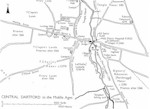
REASONS FOR GROWTH AND LIMITS TO GROWTHGeographically speaking, Dartford was a compact settlement on the main road from London to the Kent coast. The route of the road had been set out in Roman times. Medieval Dartford developed at the point where it crossed the River Darent. The town established itself on or close to the river flood plain on rich alluvial soil and gravels. Room for expansion was limited by the geology of the area. Urban development was contained between solid chalk scarps to the north and south and by boggy marshland to the east.
|
|||||
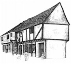
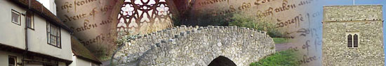
MEDIEVAL DARTFORD'S MAIN THOROUGHFARES AND FEATURESKing’s Street or the High Street was the main thoroughfare in Dartford, fronted by timber-framed tenements, shops, inns and the houses of the local gentry. The market dominated the High Street. Other principal thoroughfares included Overy Street (Overy meaning ‘over the river’), Bullis Lane (Bullace Lane), Lowfield (Lowfield Street), Hythe Street, Spital Hill (West Hill), St. Edmund's Highway (East Hill) and Rokemary Lane (site unknown). Overy Liberty was separated from the rest of the town by the river Darent. A fulling mill, used for the cleaning and thickening of cloth, was sited in Overy Street. A proper pedestrian bridge was constructed over the River Darent some time during the reign of Henry IV (1399-1413). Prior to this date, passengers had to be ferried across the river; carts crossed the river via a ford. The medieval town of Dartford was close to the countryside. Timber-framed properties in the town centre had gardens, orchards and vegetable plots adjoining. Each property occupied a long thin strip of land. In early medieval times a ‘connie-ground’ or rabbit warren was sited adjacent to the High Street. Rabbits, introduced to England by the Norman invaders, were a useful source of meat and fur.
|
|||||
AGRICULTURE AND GRAZINGMuch of the area between the town and the River Thames was occupied by extensive tracts of salt marsh and freshwater marsh. Most of the marshland was used for the grazing of animals. Common grazing rights could be exercised at the Brimpth (Brent - an area of burnt land) and on Dartford Heath. Medieval documents relating to Dartford reveal the following local field-names: Salt Mersh, Tunhaghe, Wylleyeshawes, Chalke, Fysshesland, Restch Marsh, Loam Pit Field, Lome Crofte, Westfield, Pyryfeld, Upperdeyse, Chilor and Southfield.
|
|||||
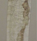
THE DARTFORD MARSH ROLL OF 1416In 1955 a document known as the Dartford Marsh Roll, dated 31 March 1416, was found in a section of old timber removed from a medieval building in Dartford High Street. This document, written in medieval Latin, lists the tenants of the Dartford Salt Marsh. Land on the marshes was used for grazing and rough pasturage. In March 1416 the tenants of the marsh were requested to pay 6d per acre held for the upkeep of marshland walls, dykes and fences. The list of tenants includes such notables as the prior of St John of Jerusalem, the prioress of Dartford, the prior of Rochester and the abbot of Lesnes, as well as the names of many local townsfolk. Document 1: Click the link below to view the document
|
|||||
KEY BUILDINGS IN MEDIEVAL DARTFORDA number of large buildings dominated the local townscape. These included Holy Trinity church, built by the Norman Bishop Gundulf c.1080; the Priory of St Mary and St Margaret the Virgins, built in 1356; the Leper Hospital of St Mary Magdalene and St. Laudus at Spital Hill (West Hill), and the Trinity Almshouse which was constructed c.1452 on the banks of the River Darent. A chantry or chapel dedicated to St Edmund stood on the top of East Hill (now the site of the Martyrs’ Memorial).
Next topic: Industry
|
|||||